top of page
BIM Services


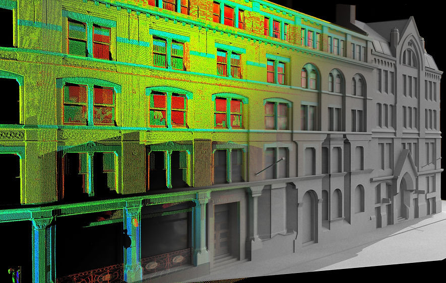
SISL provides Scan_to_BIM 3D modeling service, to convert point cloud and laser survey data into intelligent 3D BIM models.  We process the data collected by 3rd party surveyors.

We provide BIM models at a desired level of detail (LOD 100 to 350) from client’s input data, which can be any combination of – point clouds, CAD files, paper scans, photographs and sketches for existing as-built and as-is conditions in a virtual model format. We can develop BIM Model Content custom family models as per the inputs provided.

Our, some of the standard BIM services include- 

• 3D BIM of the completed as -built site 
• 2D CAD drawings from the BIM mode 
• 2D to BIM conversion 
• Fly through and animations

We deliver Output in following file formats – 
CAD formats (DWG, DXF and DGN), FBX (3D view), gbXML, Mass Model gbXML (Conceptual energy model) IFC and other formats.

BIM Services
BIM Services
BIM Services
BIM Services
BIM Services
BIM Services

Building Models

3D City
3DY Mobile Mapping

With a team of 40 analysts, the project was successfully delivered in 2 months, 16000 manhours.

3D Buildings of 400,000+ structures in Europe
3D Building Footprints

Contact

A-13, Damodar Colony,
Garh Road, Meerut, 250004
India

+91 9837008018

2D & 3D Planimetric, 3D Mapping, 2D GIS Mapping, Planimetric Mapping, Planimetric Maps, Aerial LiDAR Survey, Aerial Survey, Aerial Survey Companies, Aerial Mapping Companies, Aerial Mapping Services, Aero Triangulation, 2D Drafting Services, Aerial Photogrammetry Services, Aerial Imaging Services, LiDAR Maps, Drone surveying company, UAV surveying companies, Drone survey in India, Aerial Photography in India, Drone Image Processing, Drone LiDAR Surveying, Aerial Triangulation, Photogrammetry, Photogrammetry Surveying, Photogrammetry Services, Photogrammetry Companies in India, Digital Photogrammetry Services, Orthophoto Production, Stereo Compilation, Digital Elevation Models, Digital Mapping, Mapping Services, Map Services, GIS Mapping Services, Land Surveying Services, Land Survey in India, Land Survey Company, Land Surveyors Company, Digital Land Surveying and Mapping, Remote Sensing Image Processing, Topo Mapping, Topo Survey, Digital Mapping Solutions, GIS Mapping, GIS Consulting
  • Sai Infotech Systems, SISL, GIS Services, GIS consultant, GIS consultants, GIS company in India,
  • GIS solutions, GIS mapping services, GIS mapping companies in India, GIS data conversion,
  • GIS information services, GIS for telecom, GIS for telecommunications, GIS based mapping,

Copyright : 2006:2025. Sai Infotech Systems Ltd. All Rights Reserved

bottom of page